MarineTraffic - Ship Tracking
MarineTraffic Applications LTD
4.7
Versionsdetails
| Herausgeberland | DE |
| Veröffentlichungsdatum im Land | 2012-10-08 |
| Kategorien | Navigation, Travel |
| Länder / Regionen | DE |
| Entwickler-Website | MarineTraffic Applications LTD |
| Support-URL | MarineTraffic Applications LTD |
| Inhaltsbewertung | 4+ |
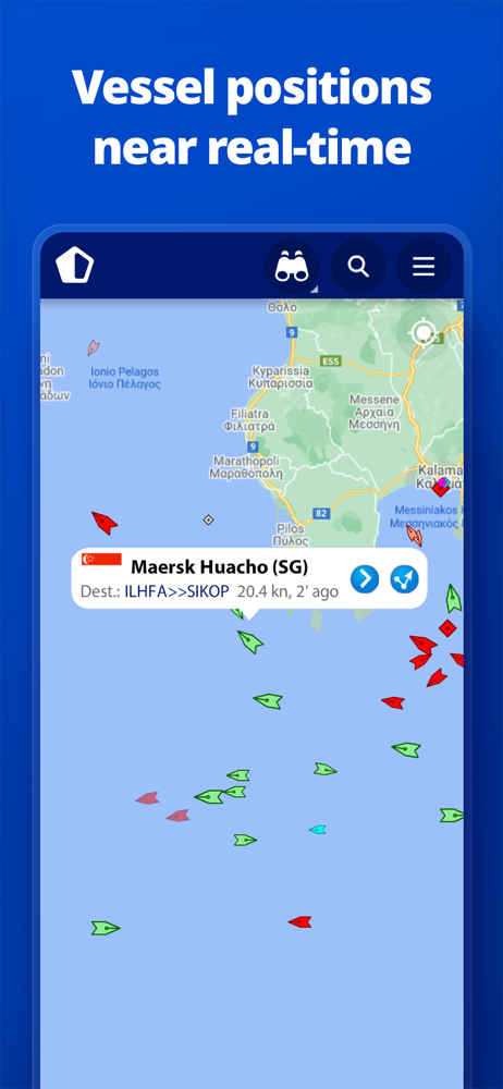
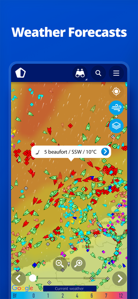
MarineTraffic displays near real-time positions of ships and yachts worldwide.
Using the largest network of land-based AIS receivers, the app covers most major ports and shipping routes.
• View VESSELS ON THE LIVE MAP, search for ships, boats and seaports and see what’s near you!
• More than 300,000 VESSELS PER DAY report their positions via MarineTraffic AIS
• View live wind and 48-hour WIND FORECASTS on the map
• ANIMATED PLAYBACK of vessel’s track
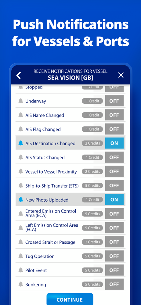
• PORT ARRIVALS & DEPARTURES live for over 4,000 ports and marinas, current conditions in ports and estimated time of arrival for the boats & ships.
• Manage your list of vessels (“MY FLEET”), shared with all your devices and MarineTraffic.com
• Browse 4.5 MILLION PHOTOS of ships, harbours, lighthouses and more!
• Upload photos to MarineTraffic directly from your device.
• Identify and track vessels sailing beyond the range of land-based AIS receiving stations, using satellite tracking, with ACCESS PLUS 24 (in-app purchase)
• Identify vessels around you at a glance with the AUGMENTED REALITY tool
Just point your device’s camera to the horizon and get all the information you need about vessels, ports and lighthouses in your area: name, flag, speed, distance from you and a lot more.
• Use the ROUTE PLANNER tool to plan a route on the map, measure distances and calculate ETA
• MarineTraffic now offers auto-renewable subscriptions for Starter Plan, Nautical Charts, Weather Maps and Advanced Density Maps:
Starter Plan
- Unlock unlimited features like extended vessel and port details, vessel track, Advanced Search, Vessels near me, Augmented Reality and more
Subscription name: Starter Plan Annual
Cost: $9.99 (USD)
Renewed every year i.e. you will be charged annually
Get access to the marine environment with Nautical Maps
- Pilotage information such as sea bed, sea marks and landmarks
- Port details such as berths, dry docks and terminal location
- Position and characteristics of buoys, lights, lighthouses
- Depths of water and heights of land
Subscription name: Nautical Charts Monthly
Cost: $6.99 (USD)
Renewed every month i.e. you will be charged monthly
Subscription name: Nautical Charts Annual
Cost: $66.99 (USD)
Renewed every year i.e. you will be charged annually
Unlock real-time & forecast weather information with Weather Maps
- Wind contours
- Wind flow & gusts
- Temperature
- Wave metrics
- Clouds and Precipitation
- Ocean currents
- More than 20 key metrics
- 7-days sea meteogram
Subscription name: Weather Maps Layers Monthly
Cost: $8.99 (USD)
Renewed every month i.e. you will be charged monthly
Subscription name: Weather Maps Layers Annual
Cost: $95.99 (USD)
Renewed every year i.e. you will be charged annually
Advanced Density Maps
- Dig into global shipping traffic data, filtering by vessel type.
Subscription name: Advanced Density Maps Monthly
Cost: $1.99 (USD)
Renewed every month i.e. you will be charged monthly
Subscription name: Advanced Density Maps Annual
Cost: $17.99 (USD)
Renewed every year i.e. you will be charged annually
For all the above subscriptions:
• Payment will be charged to iTunes Account at confirmation of purchase
• Subscription automatically renews unless auto-renew is turned off at least 24-hours before the end of the current period
• Account will be charged for renewal within 24-hours prior to the end of the current period, and identify the cost of the renewal
• Subscriptions may be managed by the user and auto-renewal may be turned off by going to the user’s Account Settings after purchase
• Any unused portion of a free trial period, if offered, will be forfeited when the user purchases a subscription to that publication, where applicable
Terms of Use: https://www.marinetraffic.com/en/p/terms
Privacy Policy: http://www.marinetraffic.com/en/p/privacy-policy
Join the great MarineTraffic community!
Durchschnittsbewertung
21.14K+
Bewertungshäufigkeit
Ausgewählte Bewertungen
Von Eddtima
2018-05-07
Version 3.6.8
monetizationDie Oberfläche stellt viele AIS-Ziele sehr übersichtlich dar und überrascht trotzdem durch viele Leistungen im Detail. Beispielsweise können Seegebiete mit Wetterdaten hinterlegt werden. Gerne würde ich noch die Möglichkeit nutzen, Wassertiefen (zumindest im Küstenbereich) zu hinterlegen - Schade - dieser In-App Purchase ist deutlich zu teuer und wohl eher für die Profischiffahrt gedacht. Vielleicht denken die Macher mal über ein abgestuftes Preismodell nach. Trotzdem volle 5* für dieses tolle Programm!
Von Aj-play
2017-06-20
Version 3.6.2
Aktuell und informativ
Von yxnn.ck
2025-06-24
Version 4.1.42
serviceSimple Bedienung, sehr informativ und gibt eine tolle Übersicht
Screenshots


AD
AD
Heiße Apps