Rivercast - River Levels App
Juggernaut Technology, Inc.
4.6
AD
Versionsdetails
| Herausgeberland | US |
| Veröffentlichungsdatum im Land | 2024-06-21 |
| Kategorien | Weather |
| Länder / Regionen | US |
| Entwickler-Website | Juggernaut Technology, Inc. |
| Support-URL | Juggernaut Technology, Inc. |
| Inhaltsbewertung | Everyone |
AD
Are you concerned about flooding? Or just want to go find the best time to go fishing or boating? Get river levels & forecasts with Rivercast™ when you need them!
Rivercast™ puts the river level data you need at your fingertips with its intuitive and interactive maps and graphs!
Rivercast™ Features Include:
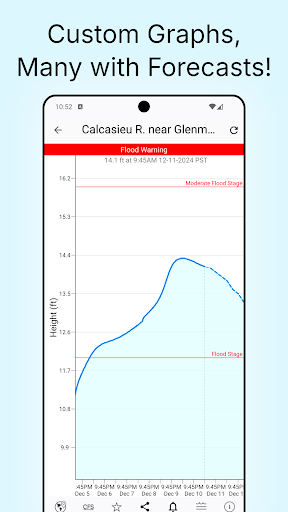
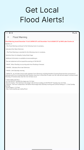
• Official Flood Warnings & other alerts from the National Weather Service
• River stage height in Feet
• River flow rate in CFS (when available)
• Indications that a river is at or approaching flood stage
• User-defined Push Notification Alerts for when river reaches levels of concern to you
• Current observations and recent history
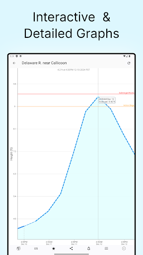
• NOAA river forecasts (when available)
• Map interface that shows where river gauges are located geographically.
• Search interface to find river gauges by waterway name, state, or NOAA 5 digit station ID.
• Interactive graphs that you can zoom in, zoom out, or pan.
• Customize your graphs by adding river levels that are relevant to you.
• Favorites list for locations you care about the most.
• Share your graphs via Text, Email, Facebook, Twitter, etc.
• Home Screen Widget to monitor your favorite locations at any time.
Rivercast’s map not only shows you where the stations are, but color codes them when it can to give you an indication whether the location is at normal levels, approaching flood levels, or above flood stage.
You can get the latest observations from the map, search, or favorites. With an additional tap of your finger you can get a detailed interactive hydrograph. You can zoom in, zoom out, or pan with your fingers to find the exact information you need.
To customize your graphs for what’s important to you, you can add your own level lines to mark sandbars, rocks, bridges, safe conditions, etc. for whatever you would like.
And you can add the streams or rivers that you would like to regularly monitor to your Favorites list for easy “at a glance” viewing.
Rivercast™ uses the latest observation and forecast data available, and requires an Internet connection for use.
Data is viewable in feet or cfs (when available).
All observation and forecast data is in your local time (per your device) for your convenience.
A handy tool for boaters, fishermen, property owners, paddlers, scientists, and the curious.
River gauges reported are USA only.
* * * * * * * * * * * * *
Some Frequent Asked Questions:
Where does Rivercast™ get its data?
• This app uses NOAA and AHPS (Advanced Hydrologic Prediction Service) for its raw data for our custom graphing and mapping solutions. There are a few locations that are available via other government agencies (including USGS) that are not available via this app.
Why does Rivercast™ sometimes show slightly different flow data (CFS) than USGS?
• CFS is a calculated estimate derived from stage height. NOAA and USGS estimates may sometimes slightly vary due to using different data models. Variances are usually within a few percent, but can sometimes be larger. Stage height should always be identical between USGS and NOAA. Designated flood stages are based on stage height in feet in the USA.
Why does Rivercast™ show only observations, but not forecasts, for my river?
• NOAA issues forecasts for many, but not all, rivers it monitors. Sometimes forecasts are only issued seasonally, or during times of flooding or high water.
Can you add location xyz to your app?
• We wish we could! If NOAA is not reporting it, we unfortunately are not able to add it. We include all stations that NOAA provides for public use.
Notice: Raw data used in this app is sourced from www.noaa.gov.
Disclaimer: Rivercast is not affiliated with nor represents NOAA, USGS, or any other government entity.
Download Rivercast - River Levels App
Not Available
Durchschnittsbewertung
576
Bewertungshäufigkeit
Ausgewählte Bewertungen
Von Shawn Carter
2024-09-05
Version 3.12
feature_requestspricingmonetizationLove the app it has help me out a lot with flooding in my area but also helps me when planning kayaking or river fishing trips. Nice easy to use interactive map. It been nice if the app had forecast data for the rivers in my area. It would also be nice to have two or 3 favorites on the free version instead of only 1 before your forced to upgrade to have unlimited. That all being said it's a great well built app a must have if you live in a flood zone I will be upgrading to premium subscription.
Von Rusty McDonald
2024-12-23
Version 3.18
performance_and_bugsgame_progressionAs a captain on the major rivers in the U.S. I rely on river stages every day, multiple times a day. I have used a different app for 10+ years, but I found this app a couple months ago because the other one has become so unreliable. I love this one. The layout is easier to use, and it loads 3x faster than my old one. I've already recommended Rivercast to several other captains!
Von Mr. M.B.
2025-07-16
Version 3.26
servicepaymentpricingfeature_requestsGreat App- Very accurate and extremely helpful for those near rivers or in flood zones! Some features are locked & require payment. In Florida there's regular flooding in some areas & information like this is vital. The app is overall functional and helpful without subscribing or paying. However, it should be available to all without restrictions or requirments of any kind- thats my only critique!
Screenshots


Heiße Apps