
onX Hunt: Offline Hunting Maps
onXmaps
4.7
Release Details
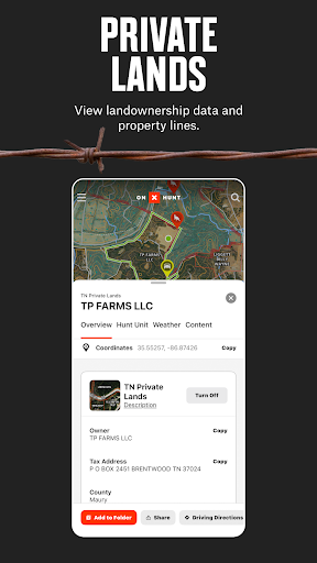
Navigate your next hunt with topo maps, GPS navigation, species distribution, hunting units, and more. Know where you stand by viewing private and public land ownership data and landowner names. Maximize your hunting experience with onX Hunt.
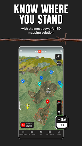
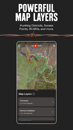
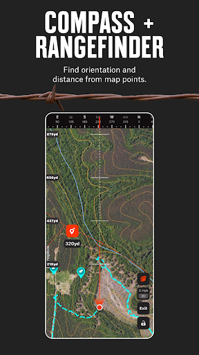
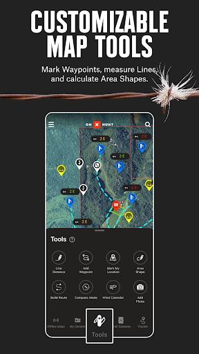
View topo maps to plan your hunt or toggle between satellite and hybrid Basemaps. Open 3D maps, mark crucial locations with Waypoints, and measure the distance to the nearest access point with Lines. Save Offline Maps to go as far from the grid as you want. Hunt by species and toggle Map Layers for deer, elk, turkeys, or waterfowl.
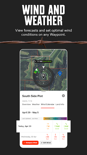
Map property lines to hunt with confidence and find new opportunities nationwide. Utilize offline navigation by downloading detailed maps with your Markups. Monitor weather conditions, wildlife distribution, and data on trees, crops or soil by switching between custom Map Layers. View Trail Cameras for recent activity and Wind Calendars for stand locations.
Access GPS navigation directly on your phone or instantly drop a Waypoint from your wrist using Wear OS. Explore a hunting app that enhances your efficiency in the field by giving you the recon tools you need.
Discover new access, find more game, and hunt smarter with onX Hunt.
onX Hunt Features:
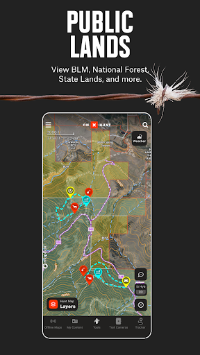
▶ Public & Private Land Boundaries
• Check property lines and land boundary maps with landowner names (U.S. only)
• View Hunting Units or GMU to plan ahead. Study county and state land hunting maps
• Navigate public land with Forest Service or Bureau of Land Management (BLM) maps
• Observe state lines and locate Wildlife Management Areas, Timber Lands, and more
Private land ownership maps may not be available for all counties (U.S. only)
▶ Offline Maps & Custom Layers
• Use 2D or 3D maps to understand the terrain and visualize your hunt
• Topo maps, satellite or hybrid Basemaps. Take advantage of easy-to-read visuals
• Save Offline Maps with your Layers, custom Markups, and Waypoints
• 7-day weather forecast. Study conditions or view wildlife and tree distribution
▶ Hunt Planner & Tracker
• Connect Moultrie trail cameras to see images in real time & receive key insights
• Measure distance between two points with the Line Distance Tools
• Map routes, mark locations, view Optimal Wind and save access points
• GPS navigation app. Log your hunt, monitor duration, distance, and speed
• Scout from the comfort of your home with our online Desktop Maps
▶ Free Trial
Start a free trial when you install the App and select your state of choice.
▶ Premium Membership:
Access all of the features listed above in a single state or Canada. Hunt more game with land ownership maps, custom map layers, offline navigation, and more!
▶ Premium+ Membership:
Get all of the benefits of our Premium Membership but for two states, or one state plus Canada.
▶ Elite Nationwide Membership:
The best tool for the best hunters. With a nationwide Membership, you get a complete, purpose-built solution for dedicated hunters and the game they pursue, including:
• Proprietary maps for all 50 states and Canada
• Advanced Tools: TerrainX 3D Viewer, Recent Imagery, Route Builder
• In-dash navigation with Android Auto
• Exclusive pro deals and expert resources
• Draw Odds and Application Tools
▶ Government Information & Data Sources
onXmaps, Inc. does not represent any government or political entity, though you may find various links to public information within our services. For more info on any government information found within the services, click on the associated .gov link.
• https://data.fs.usda.gov/geodata/
• https://gbp-blm-egis.hub.arcgis.com/
• https://www.arcgis.com/home/group.html?id=00f2977287f74c79aad558708e3b6649#overview
▶ Terms of Use: https://www.onxmaps.com/tou
▶ Privacy Policy: https://www.onxmaps.com/privacy-policy
▶ Feedback: Have a problem or want to request new features? Please contact us at [email protected]
Average Rating
62.51K+
Rating Breakdown
Featured Reviews
By Hobie Hogan
2025-10-29
Version 25.34.0
performance_and_bugsserviceExcellent for birds eye topo, don't trust it outside there. Had a rough hunt in some thick forests, looking to share with the family. One second it shows all 7 miles of deep terrain history, all logged right there... the next minute it's wiped clean and never happened. Personally won't be using On x in the future unless it's wildly helpful, which up til now, it hasn't been.
By Gene Norman
2023-10-08
Version 23.38.0
performance_and_bugsfeature_requestspaymentThis appears to be a pretty good app. My problem with it is l don't like the fact that I am signing over my credit card to them. I would purchase this app if I could make a one-time purchase for one month or one year rather than monthly or yearly recurring payments forever. They claim you can cancel any time. Good luck!! Been air dun at with other services.And I wonder if anyone besides myself has even read the agreement. If it doesn't wake you up, I'm sorry for you my friend.
By A Google user
2018-09-26
Version 4.24.0
performance_and_bugscustomer_supportserviceNot all the features work on an Android device. When I am offline I can't enter coordinates. A member of my hunting party got lost and was able to provide their coordinates, but I couldn't input them in OnX to find them. That is really frustrating to pay this much for an annual subscription and not have an essential feature work. Had to use my old reliable Garmin. Other than that HUGE deal breaker issue I have enjoyed the app. That poor experience in what could have been a life and death situation put a bad taste in my mouth. Their support staff didn't have a timeline for them to fix it. I was disappointed with their lack of information and planning for the app. At this point I will not renew my subscription!
Screenshots

AD
AD
Hot Apps