OsmAnd — Maps & GPS Offline
OsmAnd
4.4
Release Details
OsmAnd is an offline world map application based on OpenStreetMap (OSM), which allows you to navigate taking into account the preferred roads and vehicle dimensions. Plan routes based on inclines and record GPX tracks without an internet connection.
OsmAnd is an open source app. We do not collect user data and you decide what data the app will have access to.
Main features:
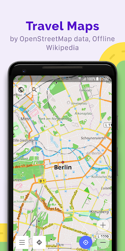
Map view
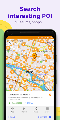
• Choice of places to be displayed on the map: attractions, food, health and more;
• Search for places by address, name, coordinates, or category;
• Map styles for the convenience of different activities: touring view, nautical map, winter and ski, topographic, desert, off-road, and others;
• Shading relief and plug-in contour lines;
• Ability to overlay different sources of maps on top of each other;
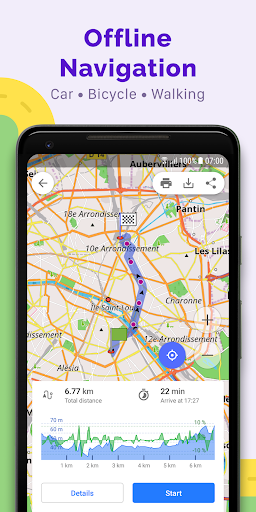
GPS Navigation
• Plotting a route to a place without an Internet connection;
• Customizable navigation profiles for different vehicles: cars, motorcycles, bicycles, 4x4, pedestrians, boats, public transport, and more;
• Change the constructed route, taking into account the exclusion of certain roads or road surfaces;
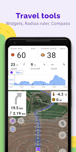
• Customizable information widgets about the route: distance, speed, remaining travel time, distance to turn, and more;
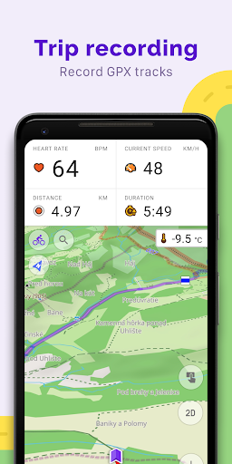
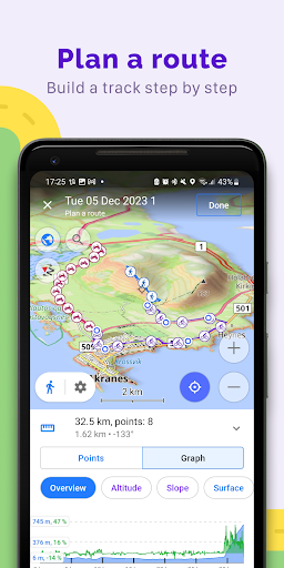
Route Planning and Recording
• Plotting a route point by point using one or multiple navigation profiles;
• Route recording using GPX tracks;
• Manage GPX tracks: displaying your own or imported GPX tracks on the map, navigating through them;
• Visual data about the route - descents/ascents, distances;
• Ability to share GPX track in OpenStreetMap;
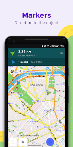
Creation of points with different functionality
• Favourites;
• Markers;
• Audio/video notes;
OpenStreetMap
• Making edits to OSM;
• Updating maps with a frequency of up to one hour;
Additional features
• Compass and radius ruler;
• Mapillary interface;
• Night theme;
• Wikipedia;
• Large community of users around the world, documentation, and support;
Paid features:
Maps+ (in-app or subscription)
• Android Auto support;
• Unlimited map downloads;
• Topo data (Contour lines and Terrain);
• Nautical depths;
• Offline Wikipedia;
• Offline Wikivoyage - Travel guides.
OsmAnd Pro (subscription)
• OsmAnd Cloud (backup and restore);
• Cross-platform;
• Hourly map updates;
• Weather plugin;
• Elevation widget;
• Customise route line;
• External sensors support (ANT+, Bluetooth);
• Online Elevation profile.
Average Rating
226.68K+
Rating Breakdown
Featured Reviews
By G Oakley
2024-10-06
Version 4.8.6
sound_and_musicperformance_and_bugsFair map app. No address look up, just destination road & cross streets. Choosing destination on the map, but it may not show. Showed 2 houses on a street where there are 12. Routing is ok, does not look at traffic, says trip is 25mi. in 28 min., hour is likely. Rereroutes when you turn off. Sticks to major roads but suggest to many U-turns when changing path. Places are out of date by up to 5 yrs & some all out wrong, never had that name. Audio is good, some nice options there too. But ...
By Jay Celani
2025-08-30
Version 5.1.9
performance_and_bugsuser_data_and_privacydesignSo far, it's a pretty awful app. Just tried my first track recording - after 2 miles, didn't record anything, though I started the recorder. The app is the opposite of intuitive or user-friendly. All I want to do is create a gps track so I can map trails. Seems like the simplest and most common use - that function should be very simple to get to and run, but in this awful app, it's not. I'll try it again once more, but I'm dubious.
By Digital Alchemy
2024-10-14
Version 4.3.8
servicemonetizationThe app itself is great. However, after I clicked on a special offer within the app to upgrade to the Pro annual subscription (a pop-up banner at the top of the screen), they continued to charge me for the monthly subscription as well—every month, for the entire year. I emailed customer support, and they told me there was nothing they could do and wouldn't issue a refund. Unethical...
Screenshots

AD
AD
Hot Apps