Navionics® Boating
Garmin
2.7
Release Details
Get up-to-date, detailed charts you can use offline plus a boatload of features on your mobile device, so they’re on hand wherever you go. The Boating app is a must-have for cruising, fishing, sailing, diving and all your activities on the water. Try it free for a limited time. To continue using charts and advanced features, you can purchase a yearly auto-renewable subscription*.
A COMPLETE PACKAGE
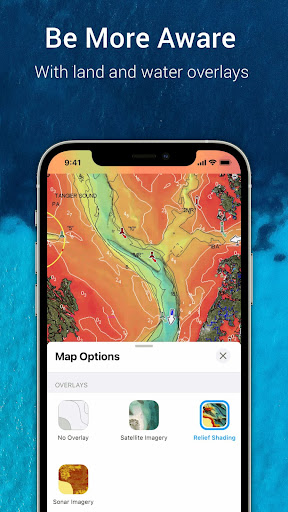
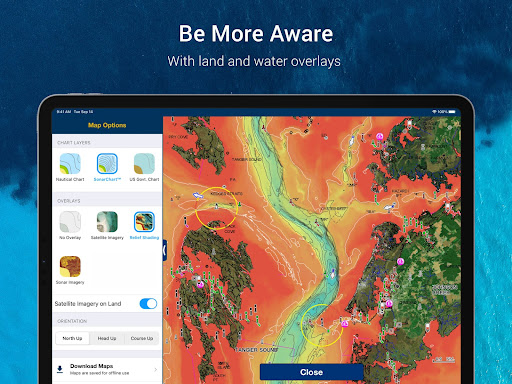
• INTERNATIONALLY RENOWNED NAVIONICS® CHARTS: Use them offline along with multiple overlays, so you can be more aware of what’s above and below the water.
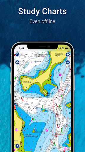
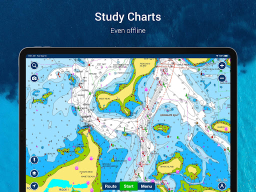
- NAUTICAL CHART: Use this premier marine reference to study port plans, anchorages and safety depth contours, locate navaids, marine services and more.
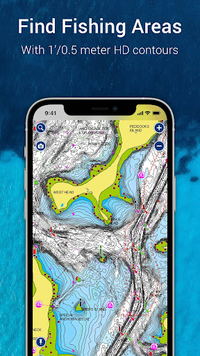
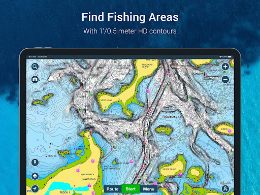
- SONARCHART™ HD BATHYMETRY MAPS: Extraordinary 1’ (0.5 meter) HD bottom contour detail is the ideal tool for locating new fishing areas.
- U.S. GOVERNMENT CHARTS (NOAA): These are available within the following coverages: U.S. and Canada, Mexico, Caribbean to Brazil.
- OVERLAYS: The relief shading overlay allows you to have a better understanding of bottom topography for improved fishing and diving. Sonar imagery reveals bottom hardness clearly and in vivid color on select lakes. Want more? Display satellite imagery on land and water.
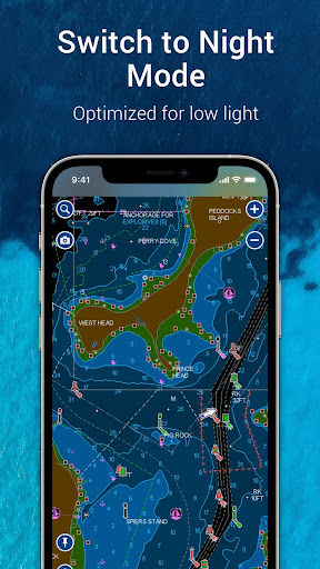
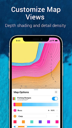
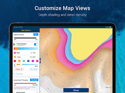
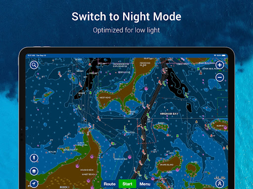
- MAP OPTIONS: Change chart-overlay combinations to customize chart views, activate night mode, highlight shallow areas, target multiple fishing ranges and more.
- DAILY UPDATES: Benefit from up to 5,000 daily updates worldwide.
• TOOLS FOR PLANNING AND ENJOYING YOUR DAY
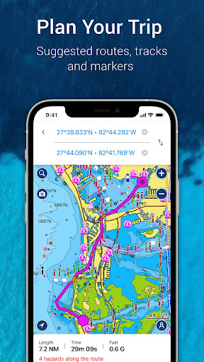
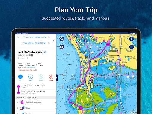
- AUTO GUIDANCE+TM TECHNOLOGY**: Easily plan your trip with a suggested dock-to-dock path based on chart data and navigation aids. Get ETA, distance to arrival, heading to waypoint, fuel consumption and more.
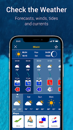
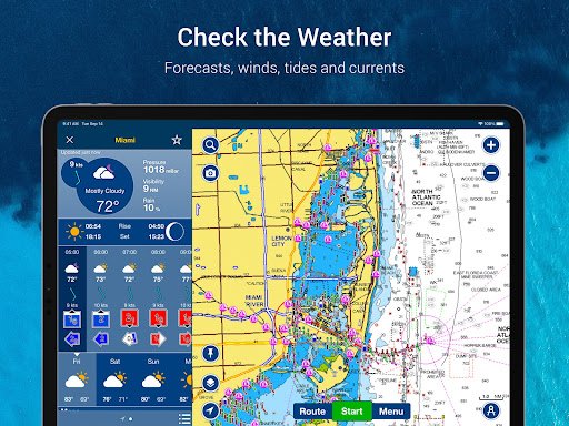
- WEATHER AND TIDES: Knowing conditions before heading out is crucial. Access real-time weather data, daily and hourly forecasts as well as wind, weather buoys, tides and currents.
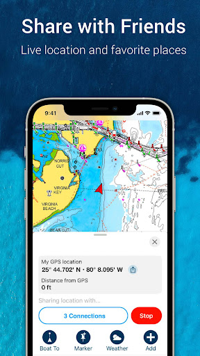
- MARKERS, TRACKS, DISTANCE: Place a marker on a good anchorage spot or where you reeled in a big fish. Record your track, take photos and videos within the app, and look back at your day anytime. Easily check distance among two points.
• AN ACTIVE AND HELPFUL COMMUNITY
- COMMUNITY EDITS and the ACTIVECAPTAIN® COMMUNITY: Obtain and contribute useful local knowledge along with thousands of fellow boaters, such as points of interest, navigation aids and valuable recommendations from people with firsthand experience of the local environment.
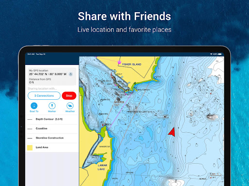
- CONNECTIONS: Stay in touch with your friends and fellow boaters by sharing your live location, tracks, routes and markers to easily meet on the water or let them check out your adventures.
- GPX IMPORT/EXPORT: Share your saved data outside the app or transfer it to your chartplotter.
- SHARE MAP OBJECTS: Share a marina, repair shop or any other location outside the app.
• EXTERNAL DEVICE-FRIENDLY FOR MORE FEATURES
- PLOTTER SYNC: If you own a compatible chartplotter, sync it with the app to transfer routes and markers, activate, update or renew your Navionics chartplotter card subscription.
- SONARCHART LIVE MAPPING FEATURE***: Connect with a compatible sonar/plotter, and create your own maps in real time while navigating.
- AIS: Connect to a compatible AIS receiver with Wi-Fi® connectivity to see nearby marine traffic. Set a safe range, and receive visual and aural alerts to signal potential collisions.
NOTES:
*You can manage your subscription anytime, and you can turn auto-renewal off.
**Auto Guidance+ is for planning purposes only and does not replace safe navigation operations
***Free features
The app is specifically designed to load and operate on devices with an OS of 10 or higher. A tablet device with Wi-Fi connectivity locates your approximate position if it is connected to Wi-Fi. A tablet Wi-Fi + 3G model operates similarly to a phone device with GPS.
Wi-Fi is a registered trademark of the Wi-Fi Alliance.
Average Rating
46.53K+
Rating Breakdown
Featured Reviews
By Jared
2024-08-21
Version 21.3
pricingmonetization*Edit for Nav's response- You're shooting yourselves in the foot. The app is COMPLETELY useless now without a subscription. You're going to lose new customers that don't know what the app CAN do, you'll lose old customers like me that will not pay $50. I used to upgrade just for satellite view. At least give the Government contours in the free version. Been using Nav for close to 15 years but I don't need it in the boat. I have a graph. DNR website has lake depth maps to replace what yours does.
By Steven Marcus
2024-10-05
Version 22.0
monetizationUsed to have old maps for life. They have now changed the TOS after the fact and now you no longer have access to maps previously purchased after the subscription ends. STAY AWAY! Completely unacceptable behavior. I'll be sure to steer clear of all Garmin products (smart watches, etc.) in the future as a contract is no longer a contract.
By Robert Taylor
2025-09-16
Version 23.1
feature_requestsupdates_and_maintenancepricingserviceThey constantly say that their app is a cutting edge navigation tool. But you can't manually enter a waypoint by coordinates, or (unlike Marks) sort the lists of Tracks and Routes by Name, only by such useful things as Distance and Date Created. Cutting Edge? Not so much. Any suggestions made to the app devs seem to go nowhere. There have not been any significant changes in the app in the 3 years I've been using it. Pay more $$$s but get nothing in return. Sadly the alternatives are no better...
Screenshots


AD
AD
Hot Apps