Avenza Maps: Offline Mapping
Avenza Systems Inc.
4.7
Release Details
| Publisher Country | US |
| Country Release Date | 2013-09-19 |
| Categories | Maps & Navigation |
| Country / Regions | US |
| Developer Website | Avenza Systems Inc. |
| Support URL | Avenza Systems Inc. |
| Content Rating | Everyone |
Avenza Maps, the best app for hiking, biking and all trails. Featuring maps from National Geographic, national parks and more! On your next adventure, stay on track with GPS using offline mobile maps. Make your own maps? Import your custom maps and never get lost off the grid.
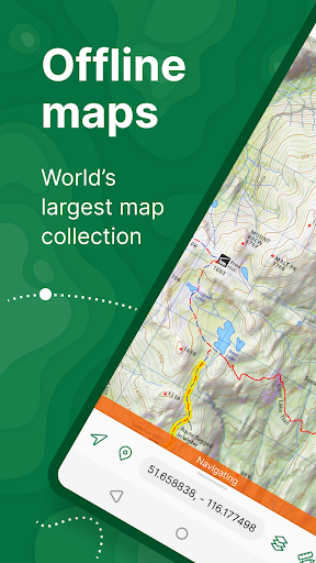
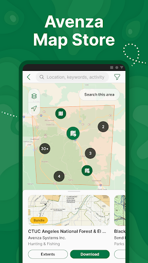
Explore the largest mobile Map Store of hiking, topographic, cycling, city, nautical, travel, and trail maps. Featuring maps from professional publishers including National Geographic, National Park Service, and the US Forest Service. Discover maps for your next camping, fishing, or backpacking trip with your family and friends. Navigate confidently when off-roading or taking those backcountry trails. Precisely identify your location with what3words and stay safe wherever you are.
Avenza Maps is free and the best map app for recreational use. Maps are available for free or purchase from the in-app Map Store. Plus subscription is available for unlimited custom map imports. Pro subscription is available for professional users with full access to all features and mapping tools.
Avenza Maps for your offline adventures on all trails!
ENHANCE YOUR MAPS WITH THESE FEATURES
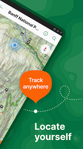
- Locate your realtime GPS position and find direction, even when offline
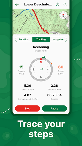
- Record GPS tracks during your activities
- Navigate to features using compass tools
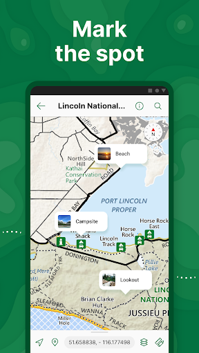
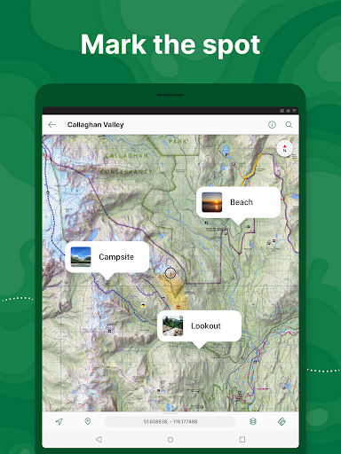
- Add photos and notes to any location
- Add placemarks to your map and style them with recreational symbols
- Measure distances and estimate times
- Supports KML, GPX, and CSV Formats
EXPLORE THE MAP STORE
Search and download maps by activity, category, and specific publishers with premium maps from:
- National Geographic
- Michelin
- Backroad Mapbooks (BRMB)
- New York-New Jersey Trail Conference
- USFS (United States Forest Service)
- USGS (United States Geological Survey)
- FAA (Federal Aviation Administration)
- NOAA (National Oceanic and Atmospheric Administration)
- BLM (Bureau of Land Management)
- HarperCollins
- DeLorme Atlas & Gazetteer / Garmin
- BaseImage
- National Park Service
- And thousands more!
A free account lets you access all of your map downloads.
GET MORE WITH AVENZA MAPS PLUS
For recreational and power users who need more
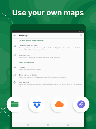
- Unlimited import of your own geospatial PDF, GeoPDF®, and GeoTIFF maps
- Create geofences for up to 50 individual features and up to four geofence layers
GET EVEN MORE WITH AVENZA MAPS PRO
For professionals and organizations who require an offline mapping solution with location awareness with more features and tools
- Unlimited import of your own geospatial PDF, GeoPDF®, and GeoTIFF maps
- GPS averaging, additional coordinate display formats, custom symbol sets
- Connect high-accuracy GPS devices including Trimble, Bad Elf, and Dual via Bluetooth
- Created unlimited geofences and get global geofence notifications
- Convert tracks to areas
- Map orientation lock
- Import and export Esri® Shapefiles
- Import and manage custom symbology sets
- Priority technical support
Avenza Maps Pro subscription required for commercial, academic, government, and professional use.
SUPPORT
We can help! Go to support.avenzamaps.com
LEGAL
Privacy Policy: avenzamaps.com/legal/privacy-policy.html
Terms of Use: avenzamaps.com/legal/terms.html
CONNECT WITH US
avenzamaps.com
facebook.com/avenzamaps
twitter.com/avenzamaps
instagram.com/avenzamaps
Average Rating
99.94K+
Rating Breakdown
Featured Reviews
By Dan Weed
2025-08-21
Version 5.4.2
serviceoffline_functionalitycontentI have been using this app for years now. I got digital maps from Colorado parks and wildlife and I put them in dropbox, then download what I need each hunting season. It puts me right on the map where I am so I know that I'm not on private land and I can't get lost. No cell service is necessary which is good in the mountains. Wonderful clear map and I can blow it up big with a squeeze of a finger. I can mark a dot on the map for anything I want to return to and I can follow my tracks. Perfect.
By Eduardo Padron
2025-06-19
Version 5.4.2
contentpaymentMy go-to mapping app for new places. Hiking, kayaking, driving and canoeing. I can almost always find the appropriate map. Do buy bundles and digitized editions of guides and maps instead of always trying to stitch-up free maps: the cost more than pays you back by savings in time and anguish. You also support the developers and sellers. You can't expect everything to be free, much less a great map and app.
By Gail Dutton
2025-04-12
Version 5.4.1
accessibilitylocalizationoffline_functionalityupdates_and_maintenanceI have been using Avenza for six years. There is a bit of a learning curve if you are not familiar with offline GPS apps. What I like is access to digital maps that are identical to hard copy versions, the ability to organize maps, tracks, etc, in folders and the ability to import GPS data from online resources. However, be aware. I have had it crash on me twice. I had hundreds of maps and thousands of tracks, waypoints, and folders lost. No online backup. you have to do it manually.
Screenshots


AD
AD
Hot Apps