My Track
Daniel Qin
3.5
Release Details
| Publisher Country | US |
| Country Release Date | 2014-02-19 |
| Categories | Travel & Local |
| Country / Regions | US |
| Developer Website | Daniel Qin |
| Support URL | Daniel Qin |
| Content Rating | Everyone |
My Track is a small and powerful application to keep track of your route while you go around. The quite complex functionality hides behind a very clear user interface which is easy to understand.
My Track can be very useful for all of your outdoor activities like hiking, bicycle and motorcycle touring, boating, skiing, climbing or sheer driving fun, it can also be used for business.
Have a look at all of these fancy features:
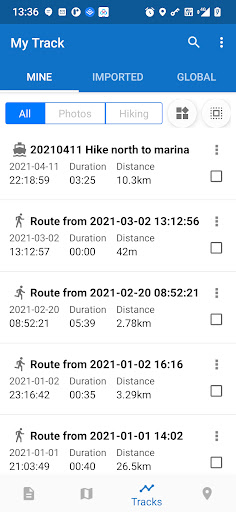
1. Record a route
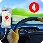
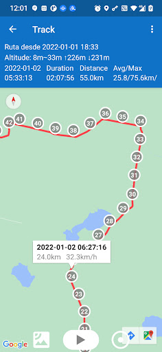
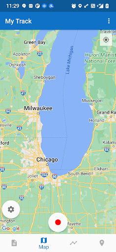
1.1 show current location on Google Map, along with time, duration and distance. even with latitude and longitude.
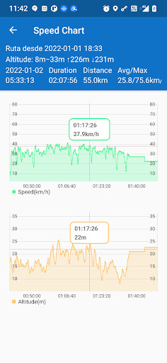
1.2 dynamic chart about speed and altitude.
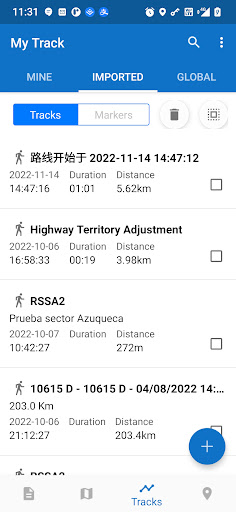
1.3 route recording, pausing, resuming, saving and listing.
1.4 photos joining with a route automatically, whatever app you use to take photos.
1.5 voice report at predefined frequency of time or distance when recording
1.6 export routes to GPX/KML/KMZ files, or import from your phone or Google Drive.
1.7 sync and restore from Google Drive.
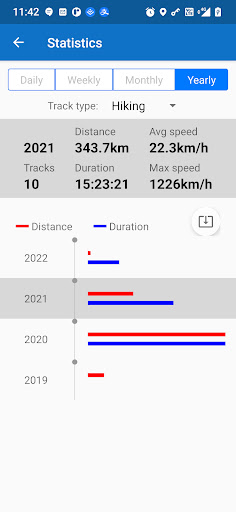
1.8 do stats.
1.9 show multi routes on the map.
1.10 print a route with the map.
2. Share a route
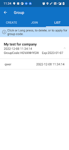
2.1 create a group and invite friends to join this group, you and your friends can share routes in this group.
2.2 share a route globally in this app.
2.3 share a route via web url to social medias, like WhatsApp, FaceBook, Gmail, etc.
2.4 select photos to share with a route.
3. Follow a route
3.1 follow your own route.
3.2 follow others’ shared route.
3.3 follow planned route.
3.4 fly your imagination: share a route in a group, friends in this group can follow this route.
4. Plan a route
4.1 plan a route(driving, bicycling and walking) among multi markers, the planed route can be followed on the map.
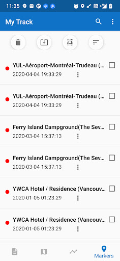
5. Markers
5.1 tap on the map to insert a marker, move the map to put the marker on proper position.
5.2 select markers to show on the map.
5.3 markers can be remembered to show next time when you open the app.
5.4 markers can be shared or exported within a route.
5.5 export markers to a KML file.
6. More
6.1 Live broadcast your locations to friends.
6.2 download offline map.
6.3 add map layer, and auto load this layer when the app starts.
6.4 click the map to measure distance, measure area, or to connect points to design a route line.
The app needs such permissions:
1. Storage permission for route saving.
2. Photo permission for joining photos with a route.
3. Location permission for route recording.
4. Internet permission for route sharing.
Attention:
1. Google Play and Google Maps should be installed first.
2. All basic features are free forever.
3. After 15 days you may see ads, you can pay to remove ads forever.
4. After 60 days you may subscribe to advanced features, or watch a video to get one time’s feature permission.
Average Rating
14.09K+
Rating Breakdown
Featured Reviews
By Michael Morse
2025-06-12
Version 8.1.2
monetizationserviceI like to review where I have driven so I've been experimenting with several tracking apps. I had almost decided My Track is the best for me when I encountered a big negative. I record my tracks on the phone, then transfer them to my larger tablet which stays home. Normally this is accomplished using the back-up and restore files. On this app back-up requires a subscription. This is not a problem, but to be able to transfer tracks you need a subscription for EACH divice. Seems a bit much.
By Roger B.
2025-05-18
Version 8.1.1
I love this app and have been using it for many years. I deducted one star because of the details page lists altitude in meters and speed (average & max) in km/h. Also, the distance meter on the map list distances in meters. I've tried to switch it to mi/hr and feet to no avail in the settings. All of the other readings are correct in mi/hr and feet. If this was corrected, I would definitely rate this five stars!
By Henry Tregillus
2022-04-20
Version 5.6.3
feature_requestsOkay, so this app IS better than most other similar apps. Out of everything, it's the most lightweight, which imho, is the most important thing for an app like it. That said...I really wish it was possible to bulk export kml files. I have like fifty that I want to get out, and given that it takes five taps for each...yeah, that's going to be annoying.
Screenshots


AD
AD
Hot Apps