
BaseMap: Hunting Maps and GPS
BaseMap Inc
4.1
AD
Release Details
| Publisher Country | US |
| Country Release Date | 2016-10-10 |
| Categories | Sports |
| Country / Regions | US |
| Developer Website | BaseMap Inc |
| Support URL | BaseMap Inc |
| Content Rating | Everyone |
AD
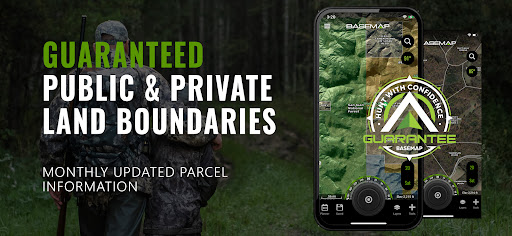
Land ownership maps, hunt planning, navigation, GPS, wind, weather, and field tools all in one convenient app.
OFFLINE GPS and TRACKING
• Save maps for offline use without service
• Know exactly where you are in real time even without cellular coverage
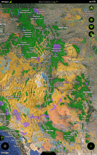
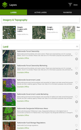
MAP LAYERS
• 900 layers and growing
• Nationwide Color Coded Govt Lands
• Nationwide Private Parcel Boundaries & Owner Names
• Coastal Water Depths & over 4,000 U.S. lakes
• Nationwide Hiking Trails
• Nationwide Wildfires & Timber cuts
• Nationwide Wilderness & Roadless Areas
• State hunting layers (boundaries, WMA’s, habitat, etc)
• Multiple Topography & Satellite Imagery basemap options
• Much more
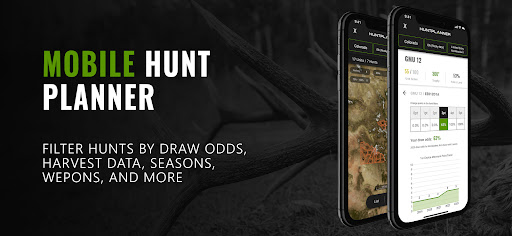
DESKTOP & MOBILE HUNT PLANNER
• Unit filtering
• Draw odds
• Harvest data
• Season dates
• Unit insights
LRF MAPPING (Laser Rangefinder Mapping)
• Use your rangefinder as a powerful mapping tool
• Precisely mark the exact location of distant targets with ANY rangefinder
• Recover game, plan stalks, lookup distant property owners and more, all using your rangefinder
MOBILE GPS
• Know your exact location even without cellular or WiFi service
• See where you are in relation to landmarks, boundaries, roads, trails, etc
• Navigate to trailheads, favorite places, markers, or anything you need to locate with our powerful Search and GoTo features.
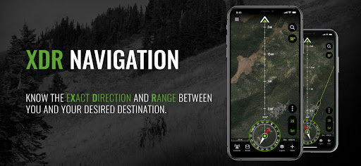
XDR (Exact Direction & Range) NAVIGATION TOOL
• Easy Point and Go navigation
• Know the exact distance between you and your destination.
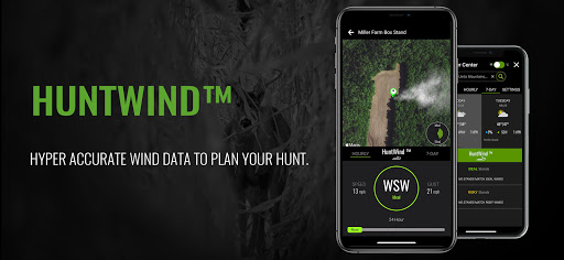
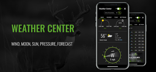
HUNTWIND & WEATHER CENTER
• Wind forecast to better plan your hunt.
• Know the exact day and time to hunt a particular stand and visualize wind direction and scent drift in relation to your location.
• Forecasts, temperature, moon phase, sunrise/sunset, wind, and more.
LOCATION SHARING
• Know exactly where your hunting partner is located
• Real-time updates
OUTDOOR JOURNAL
• Capture, log, and share all your outdoor adventures with the BaseMap community
• Real-time location sharing so friends can see where you are in case of emergency (connection reqd.)
• SmartMarkers - Automatically capture the weather conditions at the time you add a marker.
•
HARVEST LOG
• Log your hunts as detailed as you’d like. Record your hunt type, species/size, weapon, unit/GMU & much more.
GOOGLE EARTH INTEGRATION
• Export markers and view them right in Google Earth
• View the terrain in true 3D
SUBSCRIPTIONS
BASIC (Free)
• No Ads
• Connect with friends
• Hybrid 3D Imagery (map tilt).
• XDR Navigation
• Nationwide Roads, Trails & Points of Interest
• Nationwide Lakes, Rivers & Streams
• Hunting Unit boundaries
• GPS Location & Tracking
• Hi-Res Satellite Imagery
PRO ($39.99/yr)
• Everything in Basic plan
• Access to over 800 Layers
• Unlimited Data & Offline Use
• Nationwide parcel boundaries and owner names
• Nationwide color-coded government lands
• Google Earth Integration
• Import/Export KML and GPX with BaseMap web application
• Real-Time location sharing
• LRF Mapping (Laser Rangefinder Mapping)
• Discounted private land hunts
PRO ADVANTAGE ($69.99/yr)
• BaseMap Pro subscription
• Discounted private land hunts
• Global Rescue field advisory and rescue services
PRO ULTIMATE ($99.99/yr)
Includes:
• BaseMap Pro
• Discounted private land hunts
• Global Rescue field advisory and rescue services
• Hunt Planner: Unit filtering, draw odds, harvest data, season dates, and more
For questions, contact us at: [email protected]
Privacy policy: https://www.basemap.com/privacy-policy/
Terms of use: https://www.basemap.com/terms-of-use/
Government Information: BaseMap Inc does not represent any government or political entity, though you may find various links to public information within our services. For more info on any government information found within the services, click on the associated .gov link.
https://data.fs.usda.gov/geodata/
https://gbp-blm-egis.hub.arcgis.com/
Average Rating
4.48K+
Rating Breakdown
Featured Reviews
By Rob Tosoni
2024-12-27
Version 6.0.10
localizationoffline_functionalitymonetizationI tried it & I'm done! Some features are great like the wind check, and the detailed maps that seem like Google Earth. But as for property names & lines it's barely legible unless you have a magnifying glass. Using the topography map is weak. I want to save the U.S. detailed topo for my offline map... NOPE! Can't do that! I also don't care about making a journal. I just want to save my trip & my icons. Tree Stand locations, deer sign. I can't believe that I pay for this app! No more!
By Marvin Johnson
2025-02-05
Version 6.0.10
feature_requestslocalizationpricingI downloaded the free version. All I need is to keep track of my traps. I get 40 trap locations documented, and on the 41, it says I need to subscribe to continue. Not much of a free version. I do like most of it but if you draw a line and save it you have a completely new map. You can't just update the map you're working on. I can deal with a lot of things but I can't deal will only 40 trap locations. When I pull my traps I'm going to uninstall it.
By Geryl Gilbert
2023-11-19
Version 5.2.12
updates_and_maintenanceBase map is a good tool for scouting hile hunting for deer. It allows you to mark stands and take photographs of them. It tracks your activity as you go. But it has a few issues. I can't turn on the topo maps and I have the pro version. Also, about halfway into each of the tracks it seems to die and no longer keep your track. Additionally, I don't think the measurements are correct. I compared my walk between two apps and one said that I did 1.5 mi while base map said I only did 53 mi.
Screenshots

Hot Apps