onX Offroad: Navigate Offline
onXmaps, Inc.
4.3
AD
Detalles de la Versión
| País del Editor | MX |
| Fecha de Lanzamiento en el País | 2023-07-26 |
| Categorías | Travel, Navigation |
| Países / Regiones | MX |
| Sitio Web del Desarrollador | onXmaps, Inc. |
| URL de Soporte | onXmaps, Inc. |
| Clasificación de Contenido | 4+ |
AD
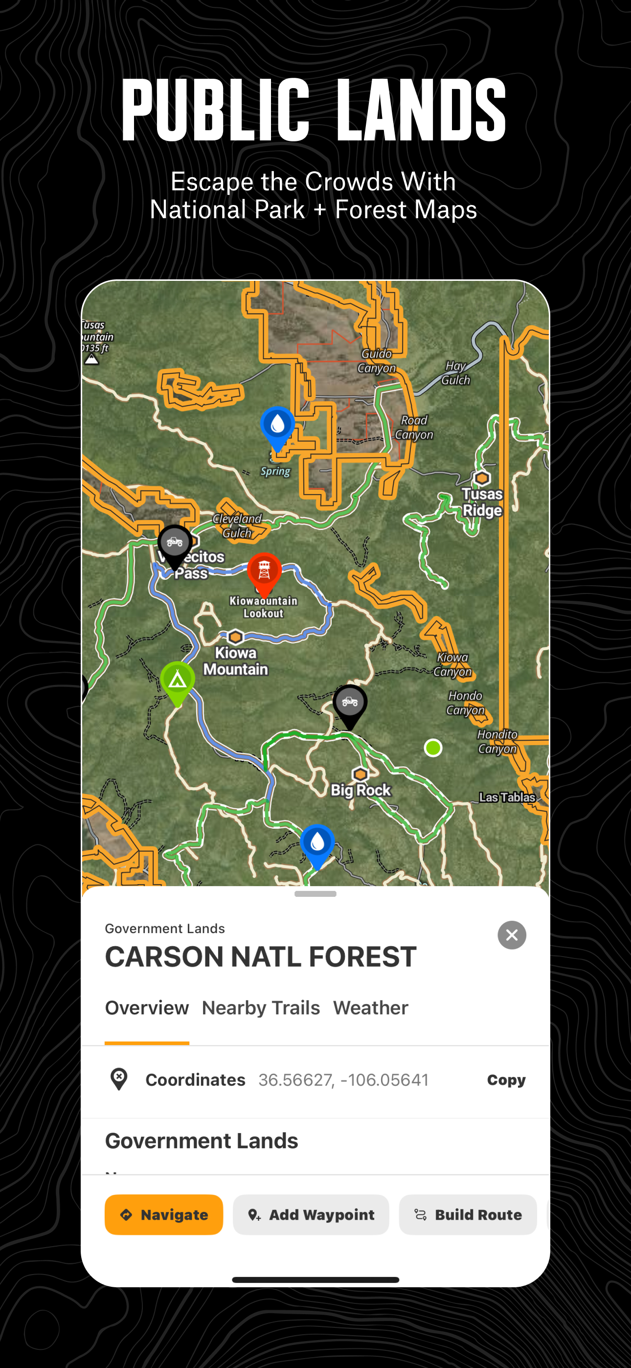
Navigate off-road and find the trails you’re looking for with onX Offroad. 3D trail maps, GPS mapping, and compass navigation — discover what’s open nearby or explore something new with ease.
Filter trails by accessibility for 4x4, SxS, dirt bikes, moto, ATV/Quads, Overland, and snowmobiles. Identify legal, free off-grid camping areas in National Forests using USFS verified data with our Motorized Dispersed Camping Layer. Go off-roading with the tools you need, including property lines, private landowner information, and acreage.
Track wildfire activity and stay safe during fire season with our built-in Active Wildfire and Wildfire Smoke Map Layers. Anticipate poor air quality and make informed decisions on the trail with NOAA’s Atmospheric Smoke Forecast data. Stay connected off the grid with Cell Coverage Layers that show up-to-date coverage for AT&T, Verizon, and T-Mobile.
Get directions from the tarmac to the trails with turn-by-turn navigation and sync onX Offroad with Apple CarPlay. Save Offline Maps to your phone or tablet. Find trailheads, trailer parking, non-ethanol fuel stations, campsites, and more.
Adventure starts where the pavement ends. Go where other maps can’t with onX Offroad.
onX Offroad Features:
▶ OHV Trails & Map Layers
• Find off-roading trails for your activity – SxS, 4x4, ATV, dirt bikes, snowmobiles, and more
• Toggle map layers for info on weather, land boundaries, and cell service
• Identify cell coverage areas for AT&T, Verizon, and T-Mobile
• Monitor wildfires and drifting smoke with data from the NIFC and NOAA
▶ Offline Navigation & Route Builder
• Explore 20K guided trails with open/close dates, difficulty ratings, and trail photos
• Save Offline Maps without losing interactive land and trail data
• Get off-road turn-by-turn directions with voice commands. Sync with Apple CarPlay
• Map routes that automatically snap to roads and trails
▶ Trip Tracker & Recreation Points
• Find legal dispersed camping spots along motorized trails in National Forests
• Track distance, location, speed or elevation. Save and share trips with friends
• Add Waypoints to mark campsites, fuel stations, fishing access, and more
• Customize maps by marking recreation points, rock crawls or obstacles
▶ Private Property Lines (Limited by Membership)
• GPS navigation and versatile map imagery – 3d, topo, satellite or hybrid
• Access private land ownership boundaries and information across the nation
• Identify National Forest, BLM, National Park land and more
Download onX Offroad and experience a trusted planning, mapping, and navigation app that always gets you home safely.
▶ Free Trial
Start a trial for free when you install the app. Experience the difference of a premier off-roading tool and plan your next adventure.
▶ Offroad Memberships:
Enjoy our premium features with an onX Offroad membership. Roam in parts unknown with the tools you need, including property maps and industry brand discounts.
• 650K+ miles of motorized roads and off-road trails
• Trails for 4x4, Side-by-Side, dirtbikes, dual sport, ATV, Quads, Overlanding, and snowmobiling
• 852M acres of public land across the U.S.
• 24K topographic maps and 3D maps for the entire U.S.
• Save Offline Maps for navigation without cell service
▶ Government Information & Data Sources
onXmaps, Inc. does not represent any government or political entity, though you may find various links to public information within our services. For more information on any government information found within the services, click on the associated .gov link.
• https://data.fs.usda.gov/geodata/
• https://gbp-blm-egis.hub.arcgis.com/
• https://www.arcgis.com/home/group.html?id=00f2977287f74c79aad558708e3b6649#overview
▶ Terms of Use: https://www.onxmaps.com/tou
▶ Privacy Policy: https://www.onxmaps.com/privacy-policy
▶ Feedback: If you have any trouble or have an idea of what you’d like to see in the app next, please contact us at [email protected].
Download onX Offroad: Navigate Offline
Not Available
Calificación Promedio
14
Desglose de Calificaciones
Reseñas Destacadas
Por Gtvictorino
2024-02-26
Versión
Great app but lacks when traveling down to Baja. There is a large part of the community down there too.
Por ValePa2
2025-03-15
Versión 25.7.0
F one could see how far off one is. Left or right.
Por Neupax
2025-01-14
Versión 24.49.1
Tiene todo lo necesario y más para crear una comunidad Offroad, creo que se debe usar más en México para que podamos aprovecharla al 100% , pero por las herramientas que te ofrece, es una excelente app
Capturas de Pantalla


Aplicaciones Populares