MarineTraffic - Ship Tracking
MarineTraffic Applications LTD
4.7
AD
Détails de la Version
| Pays de l'Éditeur | FR |
| Date de Sortie dans le Pays | 2012-10-08 |
| Catégories | Travel, Navigation |
| Pays / Régions | FR |
| Site Web du Développeur | MarineTraffic Applications LTD |
| URL de Support | MarineTraffic Applications LTD |
| Évaluation du Contenu | 4+ |
AD
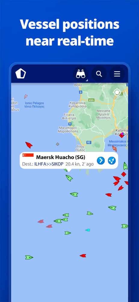
MarineTraffic displays near real-time positions of ships and yachts worldwide.
Using the largest network of land-based AIS receivers, the app covers most major ports and shipping routes.
• View VESSELS ON THE LIVE MAP, search for ships, boats and seaports and see what’s near you!
• More than 300,000 VESSELS PER DAY report their positions via MarineTraffic AIS
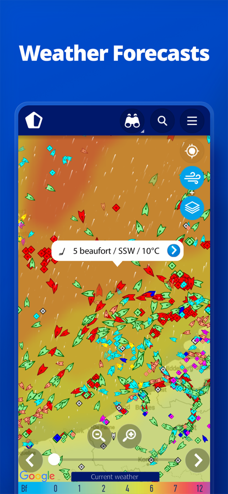
• View live wind and 48-hour WIND FORECASTS on the map
• ANIMATED PLAYBACK of vessel’s track
• PORT ARRIVALS & DEPARTURES live for over 4,000 ports and marinas, current conditions in ports and estimated time of arrival for the boats & ships.
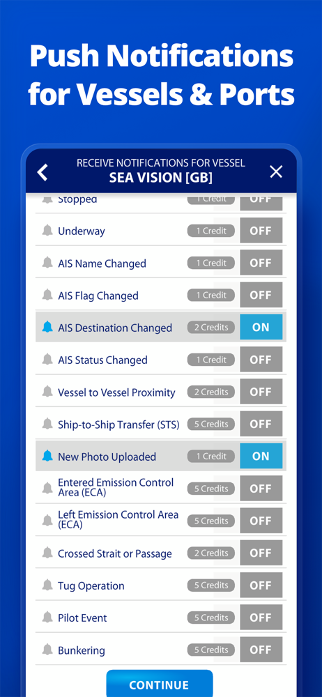
• Manage your list of vessels (“MY FLEET”), shared with all your devices and MarineTraffic.com
• Browse 4.5 MILLION PHOTOS of ships, harbours, lighthouses and more!
• Upload photos to MarineTraffic directly from your device.
• Identify and track vessels sailing beyond the range of land-based AIS receiving stations, using satellite tracking, with ACCESS PLUS 24 (in-app purchase)
• Identify vessels around you at a glance with the AUGMENTED REALITY tool
Just point your device’s camera to the horizon and get all the information you need about vessels, ports and lighthouses in your area: name, flag, speed, distance from you and a lot more.
• Use the ROUTE PLANNER tool to plan a route on the map, measure distances and calculate ETA
• MarineTraffic now offers auto-renewable subscriptions for Starter Plan, Nautical Charts, Weather Maps and Advanced Density Maps:
Starter Plan
- Unlock unlimited features like extended vessel and port details, vessel track, Advanced Search, Vessels near me, Augmented Reality and more
Subscription name: Starter Plan Annual
Cost: $9.99 (USD)
Renewed every year i.e. you will be charged annually
Get access to the marine environment with Nautical Maps
- Pilotage information such as sea bed, sea marks and landmarks
- Port details such as berths, dry docks and terminal location
- Position and characteristics of buoys, lights, lighthouses
- Depths of water and heights of land
Subscription name: Nautical Charts Monthly
Cost: $6.99 (USD)
Renewed every month i.e. you will be charged monthly
Subscription name: Nautical Charts Annual
Cost: $66.99 (USD)
Renewed every year i.e. you will be charged annually
Unlock real-time & forecast weather information with Weather Maps
- Wind contours
- Wind flow & gusts
- Temperature
- Wave metrics
- Clouds and Precipitation
- Ocean currents
- More than 20 key metrics
- 7-days sea meteogram
Subscription name: Weather Maps Layers Monthly
Cost: $8.99 (USD)
Renewed every month i.e. you will be charged monthly
Subscription name: Weather Maps Layers Annual
Cost: $95.99 (USD)
Renewed every year i.e. you will be charged annually
Advanced Density Maps
- Dig into global shipping traffic data, filtering by vessel type.
Subscription name: Advanced Density Maps Monthly
Cost: $1.99 (USD)
Renewed every month i.e. you will be charged monthly
Subscription name: Advanced Density Maps Annual
Cost: $17.99 (USD)
Renewed every year i.e. you will be charged annually
For all the above subscriptions:
• Payment will be charged to iTunes Account at confirmation of purchase
• Subscription automatically renews unless auto-renew is turned off at least 24-hours before the end of the current period
• Account will be charged for renewal within 24-hours prior to the end of the current period, and identify the cost of the renewal
• Subscriptions may be managed by the user and auto-renewal may be turned off by going to the user’s Account Settings after purchase
• Any unused portion of a free trial period, if offered, will be forfeited when the user purchases a subscription to that publication, where applicable
Terms of Use: https://www.marinetraffic.com/en/p/terms
Privacy Policy: http://www.marinetraffic.com/en/p/privacy-policy
Join the great MarineTraffic community!
Évaluation Moyenne
11.31K+
Répartition des Évaluations
Avis Sélectionnés
Par CASTOR LAPON
2023-08-01
Version 4.0.58
UpdatesJ’aime cette appli. J’aimerai avoir une version en français et pouvoir mettre des informations sur mon bateau et des lieux de déplacement.
Par BON1002BON100
2023-07-10
Version 4.0.58
FamilyNotificationsMalgré un abonnement annuel à 10€99, plus quelques redevances journalières à 0€99 chacune, grâce auxquelles, j’ai quand même pu recevoir pendant 3 jours quelques notifications de positions satellites pour les plotter moi même ensuite sur Google Earth, je n’ai rien eu d’autres ! En particulier sur l’application elle même le voilier suivi est toujours mouillé dans l’Anse Marcel à Saint Martin alors que compte tenu du dernier point satellite reçu samedi 8 il devrait se trouver à moins de 500NM de Horta. Bref, rien à voir avec son homologue aéro Radar24 qui même en gratuit fonctionne 1000 fois mieux.
Par valgsc
2022-09-07
Version 4.0.32
NotificationsL’application est globalement bien faite. Cependant je suis très déçu de voir que même après avoir payé l’abonnement standard à +10€/an je dois encore payer pour avoir des notifications! Je n’ai paramétré des notifications que pour un seul navire et au bout de 3 jours je suis informé que j’ai atteint le “crédit” et que je dois encore payer un supplément pour continuer à les recevoir. C’est assez scandaleux sachant qu’une notification est une fonction assez simple et courante sur n’importe quelle application, sans parler du fait qu’elle incite à utiliser cette application et participe donc à créer du trafic d’utilisateurs.
Captures d'Écran


Applications Populaires