GPS Tracks
David Morneault
4.7
AD
リリース詳細
| 発行国 | US |
| 国のリリース日 | 2011-05-26 |
| カテゴリ | Health & Fitness, Navigation |
| 国/地域 | US |
| 開発者ウェブサイト | David Morneault |
| サポートURL | David Morneault |
| コンテンツ評価 | 4+ |
AD
“One of the better GPS apps for sporting enthusiasts for the iPhone…”
- Bryan Wolfe, AppAdvice.com
Do you want to track your hiking, biking, walking, running?
Do you want to track your outdoor activities?
Do you need to navigate to waypoints?
Do you want to store your favorite destinations?
GPS Tracks is an ideal app for your outdoor navigational needs, it makes navigating to a specific point and tracking your outdoor activities very simple. It will keep track of your activities and allow you to easliy navigate to coordinates.
Use Applications -
• Great for hiking offline, running, walking, and biking to track your route!
• Great for photographers who need to track location data for their pictures!
• Great for hunters and fishermen who need to store specific locations!
• Great for golfing to find the distance to the pin!
• Great for military navigational applications!
Features
Live Activities & Widgets
• Live Activity for tracking
• Live Activity for navigating to waypoints
• Lock Screen & Home Screen widget for distance today
• Lock Screen & Home Screen widget for current location
• Home Screen widget for last track and add new waypoint
Track
• Track your location/route of your activity
• Store favorite locations
• Take GPS static observations to average current location for more accurate waypoints
• Easily navigate to waypoints with the waypoint guide on the compass
• Add fully editable waypoints on the fly to your current track either manually or from you favorite locations
• Add a vector as a waypoint with angle and distance
• Convert between four sets of coordinates (Decimal, DMS, MGRS, UTM) anytime
• Glide Ratio is viewable and tracked during recording
• Use degrees or mils for the compass
• Add MGRS Grid overlay to map
• Create routes to follow manually before you start your track
• GPS Tracks uses WGS84 datum, over 220 datums available with an In-App purchase.
Measure
• Map measuring tools allow you to measure area and distance on the map
• Draw or drop pins to measure
Apple Watch App
• Track your activity directly with your Apple Watch without your iPhone
• Will save your workouts to the Health app from the watch (only the watch app uses HealthKit)
Connect
• iCloud syncing (will sync between Mac, iPad, and iPhone version)
• Import/Export to Dropbox, iCloud Drive, or iTunes File Sharing
• Send locations to the Navigon/TomTom/Google app or the default Maps app for driving directions
• Share your location with friends with a text message (SMS) or email with a direct link to your location on a map
• Import and export tracks/coordinates in a GPX, KML, BIN, CSV, or NMEA format
• Email exported files
• Export track with photos to KMZ file to export your photos taken during the track
Review History
• View your track on the map with the ability to replay the route
• View detailed statistics of the track
• View the waypoints saved with each track
• Change track color
There are many other great features.
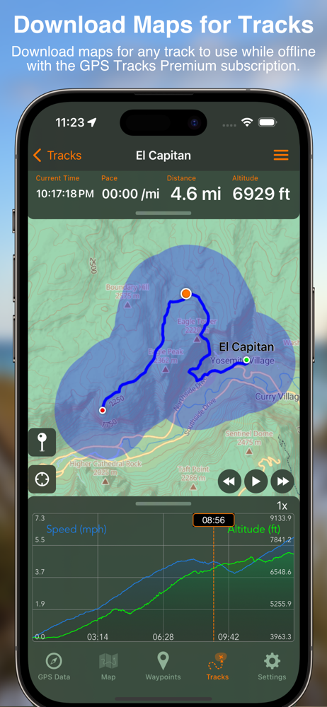
GPS Tracks Pro & Premium (Auto-Renewing Yearly Subscription In-App Purchase)
• Use Street, Terrain, Satellite, USGS, NOAA nautical charts, FAA charts, and many other alternate map sources
• Save maps for offline use
• Add map overlays of local trails or area boundaries from images, files, or directly from your camera
• Use custom Map Tile Server URLs
• Print Maps in PDF
• GPS Tracks Live - location sharing with friends which allows you to see your friends tracks live on the map
• Weather at waypoints
• Elevation profiles for tracks
• Subscription syncs via iCloud to other devices
Privacy Policy and Terms of Use - http://www.dmsoftwaresolutions.com/privacyPolicyTermsOfUse.html
Continued use of GPS running in the background can dramatically decrease battery life.
平均評価
16.33K+
評価の内訳
注目のレビュー
BenGenGalによる
2021-09-10
バージョン 3.7.1
gamificationaccessibilityMy new favorite place to walk is a park that has a lot of paths but the paths are not mapped out very well. The only way I knew to create an accurate map of the paths were to simply walk them, and have my phone track me while I walked. I did this using this app, and only on days where I had a lot of time, since once I picked a path I didn’t know how far it would go or how long I would walked. I simply kept doing this until I had walked all of the paths. There were so many trails that I didn’t walk them all on one day. I usually walked one trail a week. But the cool thing was that I was still able to create a map that showed all trails at once, so that from then on I was able to pick and choose what trails I wanted to take and even go from one trail to another during a walk. Other apps didn’t give me that freedom. They only showed one track at a time, and that made it impossible to connect the tracks together. Only with this app was I able to get the full picture so that I’d be able to pick which paths I wanted to take on any given day or view how long each path I picked would be on the days I didn’t have a lot of time.
deejaysteveoによる
2018-11-15
バージョン 3.2.9
cross_platform_consistencylocalizationoffline_functionalitymonetizationperformance_and_bugsAs a long time Biological Field Technician I have nothing but good things to say about this app. I use it daily in the rugged and remote terrain in Hawaii. I have ditched my clunky Garmin handheld unit and can run tracks and take photo waypoints for my work all day long. I’m freed up from needing a PC to transfer data and I can now deliver info straight from the field via text msg or email. Loading external maps and data that have been emailed to me is a cinch. I use GPS Tracks to inspect conservation fences, track invasive species control and search for endangered plants as well as field navigation. I have even used it while flying to locate helicopter landing zones. The app doesn’t have a huge impact on my iPhone 8 battery life. So far it has performed very well when offline/No Service which is imperative in the Hawaiian backcountry. Although I am concerned about using it in a dense forest canopy, perhaps an accessory antenna may help. Love the mapping subscription and benefit highly from the ESRI contour map. Usability is easy to learn and I have gotten a number of coworkers to use the app on their phones.
Drewcifer68による
2018-05-26
バージョン 3.1.8
feature_requestslocalizationoffline_functionalitymonetizationI reviewed several GPS apps and bought too many useless ones before I found this one. Whatever your application, this is your app. On road or most especially off. It is feature rich and takes a little time to learn all it can do but it's worth every moment and penny. We use it for planning and tracking kayaking trips, mostly on local rivers and waterways. You can review, plan, map, and execute your track by land or water anywhere you can bring up on the map with this tool. Satellite or roadmap views. How far it is from bridge A to bridge B on that river? Go to Tracks tab and trace every bend and oxbow and know exact distance before you hit the water. Looks good? Name it and save it and this app will guide you down the track you planned. Ditto for hiking. Need a more detailed map? With a reasonable annual subscription a huge array of professional maps for various applications are available for purchase and can be download for permanent offline access. Driving, hiking, biking, navigating the waterways, this is your guide.
スクリーンショット


人気アプリ