Guru Maps 地図とナビゲーションオフライン
Evgen Bodunov
3.8
AD
リリース詳細
| 発行国 | JP |
| 国のリリース日 | 2015-08-21 |
| カテゴリ | Travel & Local |
| 国/地域 | JP |
| 開発者ウェブサイト | Evgen Bodunov |
| サポートURL | Evgen Bodunov |
| コンテンツ評価 | 3 歳以上 |
AD
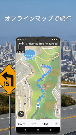
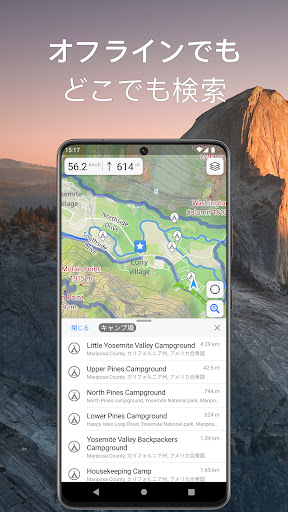
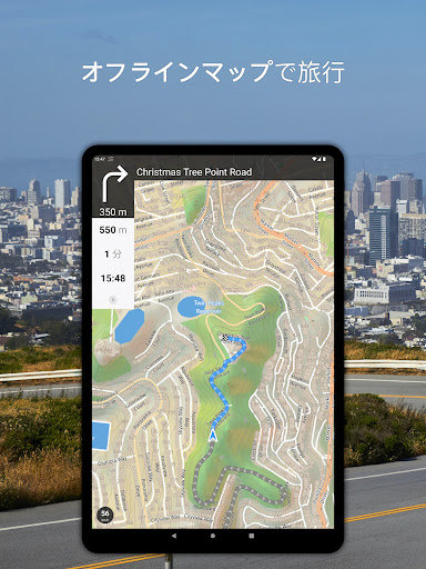
Guru Maps helps you find the best trail and spend some time enjoying the great outdoors like traveling, hiking, biking or off-roading. With detailed maps covering the entire world, offline navigation, and real time GPS tracking, you’ll have everything you need to plan and organize your adventures.
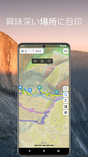
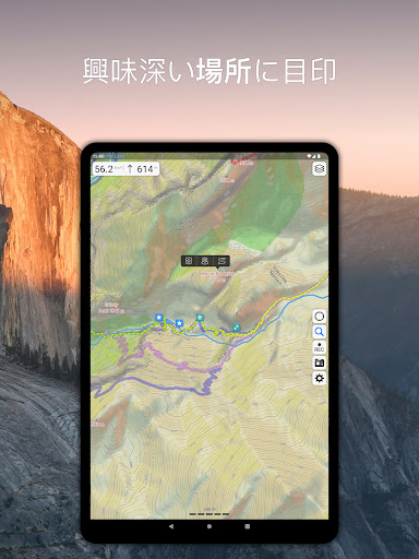
Offline Maps
• High-resolution & based on OpenStreetMap (OSM) data.
• Updated monthly with the most-recent fixes and additions.
• Adjustable font size of the labels for better readability.
• Multiple custom map layers can be shown above the base one (GeoJSON support).
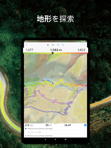
• Hillshade, contour lines and slope overlays for relief visualisation.
Offline Navigation
• Turn-by-turn voice-guided driving directions with alternate ways.
• Multi-stop navigation with the route optimization feature (circuit route planner).
• Voice instructions while navigating available in 9 languages.
• Routes for Driving/Cycling/Walking/Shortest Distance.
• Automatic rerouting gets you back along your way, even offline.
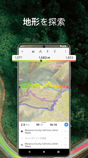
Drive Offroad• There is an option for choosing the type of bike to build the perfect route, given the pavement (road surface): road, city, touring, mountain (MTB), trekking or gravel bikes.
• Plan an off-road overland trip in your 4x4 vehicle (quad, ATV, UTV, SUV, jeep) or moto, relying on topographic data in order to avoid trickier terrain. Find trails, campsites, adequate gas stations and other destinations along the route, even during an offline mode.
• The trip monitor shows the orientation (compass), accurate speed in mph, km/h or knots units (speedometer), distance (odometer), bearing line and azimuth during the trip. The app collects data from multiple satellites orbiting the Earth.
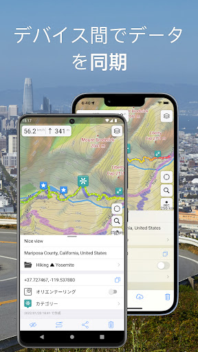
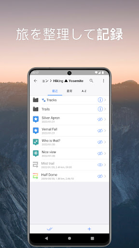
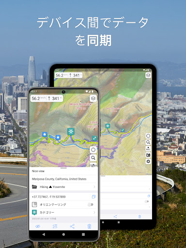
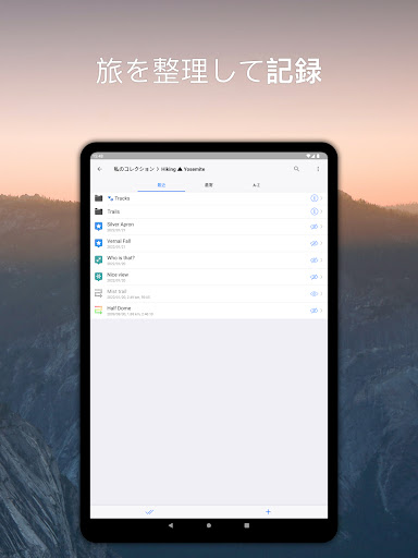
Synchronization
• Seamless sync your data across multiple iOS/Android devices as long as they are authorized with the same account.
• All the data such as saved places, recorded GPS tracks and created routes will be synced on all your devices on both OS platforms.
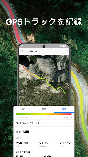
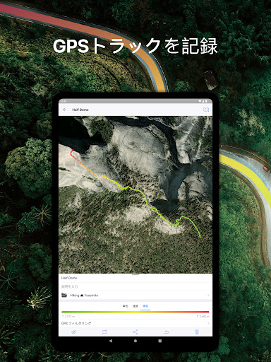
GPS Tracker
• Track the exact location of your phone & tablet real time.
• Record your footpath even when the app is in the background.
• Monitor detailed statistics of your ride: current speed, distance, time traveled, altitude.
• Choose from seven solid track colors, or altitude and speed gradients.
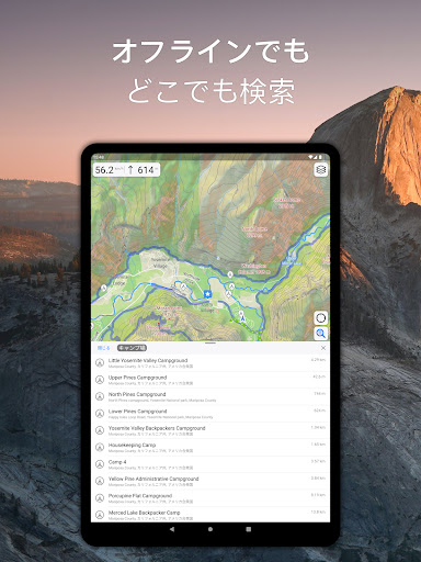
Offline Search
• Incredibly fast – results appear instantly as you type.
• Searches simultaneously in multiple languages, making searching easier than ever.
• Search in a variety of ways – by address, object name, category, or even by GPS coordinates. Supported coordinates formats: MGRS, UTM, Plus codes, DMS, latitude & longitude (decimal degrees (DD), degrees and decimal minutes, sexagesimal degree).
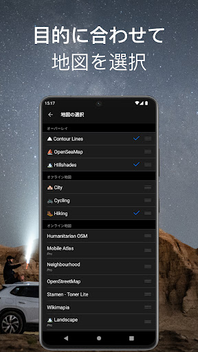
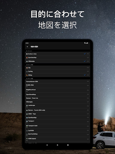
Online Maps
• Pre-installed online map sources: OpenCycleMap, HikeBikeMap, OpenBusMap, Wikimapia, CyclOSM, Mobile Atlas, HERE Hybrid (satellite), USGS - Topo, USGS - Satellite.
• Even more sources available for adding: OpenSeaMap, OpenTopoMap, ArcGIS, Google Maps, Bing, USGS etc from here: https://ms.gurumaps.app.
Supported File Formats
Support for a variety of file formats, including:
.GPX, .KML, .KMZ - for GPS-tracks, markers, routes or whole travel collections,
.MS, .XML - for custom map sources,
.SQLiteDB, .MBTiles - for offline raster maps,
.GeoJSON - for overlays.
PRO Subscription
• With a pro subscription, you’ll have access to unlimited markers, GPS tracks, and offline map downloads, as well as additional sources and file formats.
• Without subscription it’s possible to create up to 15 pinned places, record up to 15 tracks and have only 3 vector countries (regions) downloaded on your device.
• Choose from monthly, yearly, or one-time purchase (aka lifetime license) options.
Download Guru Maps 地図とナビゲーションオフライン
Not Available
平均評価
12.74K+
評価の内訳
注目のレビュー
Tarepanda Tarepandaによる
2025-10-12
バージョン 5.9.1
feature_requests欲しい機能が網羅されています ルートの自動最適化をオフにできるスイッチがあると意図通りにルートが引けるので嬉しい
Googleユーザーによる
2020-01-11
バージョン 4.0.5
Nシステムマップをダウンロードして使える。 kmlまたはkmzファイルをNシステムマップからダウンロードし、guru mapsのマイコレクションとして表示可能。 しかし、ナビ中にNシステムの場所を表示させるにはコツがいる。 自分のAndroid9スマホの場合、ナビに設定してから、スマホの通知領域に表示されるguru mapsのアイコンをタップしないと、なぜかナビ中にNシステムの場所が表示されない。 また、本家のNシステムマップには表示されているのに、guru mapsのマイコレクションでは表示されないアイコンが何個かあるのもマイナス点。 とは言え、現時点でナビ中にNシステムの場所を表示可能な無料Androidナビはこれしかないので、重宝している。
Googleユーザーによる
2020-02-12
バージョン 4.0.5
とても便利。オフラインでも使えるので海外出張時も場所が判ってとても重宝してます。ブックマークがクラウド経由で保存でき、kml形式でグーグルアース上に示せるのも便利。
スクリーンショット