HuntStand: GPS Maps & Tools
GSM Outdoors
3.4
릴리스 세부정보
| 발행국 | US |
| 국가 출시일 | 2015-08-20 |
| 카테고리 | Sports |
| 국가 / 지역 | US |
| 개발자 웹사이트 | GSM Outdoors |
| 지원 URL | GSM Outdoors |
| 콘텐츠 등급 | Everyone |
Discover the all-new HuntStand app, now with a completely redesigned look and feel to enhance your scouting and navigation experience in the field. Recognized by Outdoor Life Magazine as the Best App for Hunters, HuntStand is North America’s #1 Hunting & Land Management App, with over 6 million downloads. Whether you’re searching for property lines, finding new hunting spots, or tracking deer movement, make HuntStand your go-to app for a successful hunting season. Install now for free!
► Popular Features ►
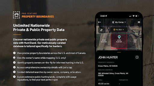
◆ Nationwide Property Lines: Access private and public property boundaries and curated public land maps nationwide for all 50 states and most of Canada.
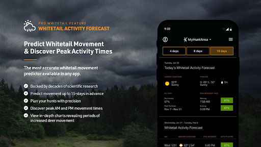
◆ Advanced Whitetail Forecasts: Exclusive 15-Day Whitetail Activity Forecast specific to your exact location. Know when to hunt.
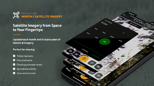
◆ Monthly Satellite Imagery: View changes in your hunting ground with new satellite imagery delivered each month. Includes historical archive with years of imagery.
◆ Group Hunt Areas: Share hunt areas with buddies, lease partners, and family seamlessly.
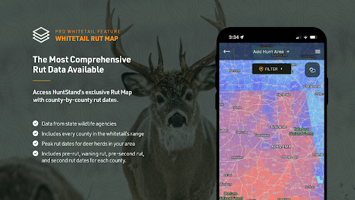
◆ Nationwide Rut Map: The only county-level whitetail rut map with comprehensive rut dates, by phase, visualized through a color-coded system.
► Start Mapping for FREE ►
Download HuntStand and start mapping your hunting areas today, completely free. Experience the value and power of HuntStand through these essential features.
◆ GPS Mapping: View your current position on the map. Trace your path as you move in real time. Add map markers to save important locations like tree stands.
◆ HuntZone Wind Forecasting: Map out your scent impact with HuntZone, providing hour-by-hour scent predictions for up to 72 hours in advance.
◆ Hunt Area Customization: Design detailed maps of your hunting areas, tailored to your specific needs, and share them with hunting buddies, lease partners, and family members.
◆ High-Resolution Satellite: View detailed, high-resolution satellite imagery of your hunting areas to plan and navigate with precision.
◆ Digital Rangefinder: New rangefinder mode allows for easy distance calculations in the field.
► HuntStand Pro ►
For only $29.99 per year, enjoy the most cost-effective hunting app available. Get all the great features of the HuntStand free hunting app plus the following nationwide hunting maps and features.
◆ Nationwide Property Lines: Access detailed property line maps for all 50 states and most of Canada.
◆ Property Ownership Data: View comprehensive property ownership information for all 50 states and search for property owners by name.
◆ Monthly Satellite Imagery: Stay updated on the latest changes in your hunting areas with fresh satellite imagery. Includes historical archive.
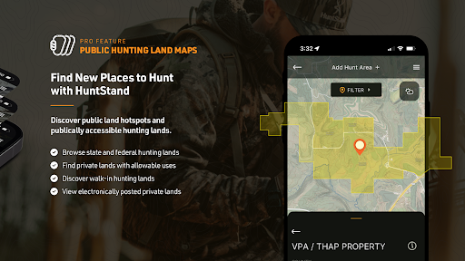
◆ Public Hunting Land Maps: Explore a variety of public hunting lands. Find your new hotspot.
◆ National Aerial Imagery: Access high-resolution aerial imagery for the entire U.S.
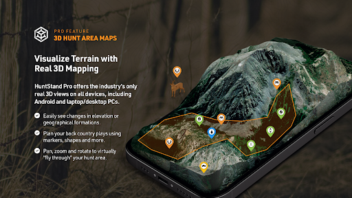
◆ 3D Mapping: Navigate and “fly through” your hunting terrains in dynamic 3D for enhanced planning.
◆ Unlimited Offline Maps: Save your hunting maps for use without an internet connection.
► HuntStand Pro Whitetail ►
For the ultimate deer hunting experience, upgrade to HuntStand Pro Whitetail. Includes all HuntStand Pro features plus powerful tools made specifically for whitetail hunters.
◆ All HuntStand Pro Maps: Access all HuntStand Pro maps.
◆ All HuntStand Pro Features and Tools: Utilize all HuntStand Pro features and tools.
◆ 15-Day Whitetail Activity Forecast: View peak times to hunt and predict deer movement with pinpoint accuracy.
◆ Annual Whitetail Rut Map: Visualize county-level rut data on a color-coded map (U.S. only). Includes rut dates for each phase of the rut.
◆ Whitetail Habitat Map: Identify optimal habitats for white-tailed deer to find new hunting areas easily (U.S. only).
Billing & Subscription: Charges apply to your Google Play account upon purchase.
Privacy Policy: https://huntstand.com/privacy
Terms & Conditions: https://huntstand.com/terms-and-conditions
평균 평가
21.74K+
평가 내역
추천 리뷰
Eyecon Music 작성
2025-10-16
버전 8.0.54
performance_and_bugscustomer_supportYou guys did a great job screwing up a perfect app! I've been using the paid version for years and it's been great...but NO, you just had to f--- with it. None of my stand locations load now, the wind cone won't show up, it automatically shows me at my location, even when trying to view a different farm...nothing works as it should. TERRIBLE APP NOW
Nathan hopple 작성
2025-10-25
버전 8.0.54
monetizationpricingperformance_and_bugsserviceuse to be good now it's un usable. a decade worth of time and updating tree stands, property marks, deer paths , harvest. gone in the blink of an eye unless you want to pay the $100 a year. use to be able to save all that stuff along with using wind direction and other features for free then it was the lower tier paid which we were fine with because it was reasonably priced. now $100 a year? nope . not doing it. especially since it crashes all the time. we are seeking a new app
Jarrett Mims 작성
2025-10-27
버전 8.0.54
performance_and_bugspricingserviceI've been using huntstand from the very start. I have loved this app over others for many years until the last year or two. It seems as if the app is now slow. It doesn't load things or show stuff it usually would take a second to bring up. I pay for the services, and it has gradually gotten worse and has almost become more of a burden to try and use. I hate to say these things, but it's true. Im a mad and frustrated customer.
스크린샷


AD
AD
인기 앱