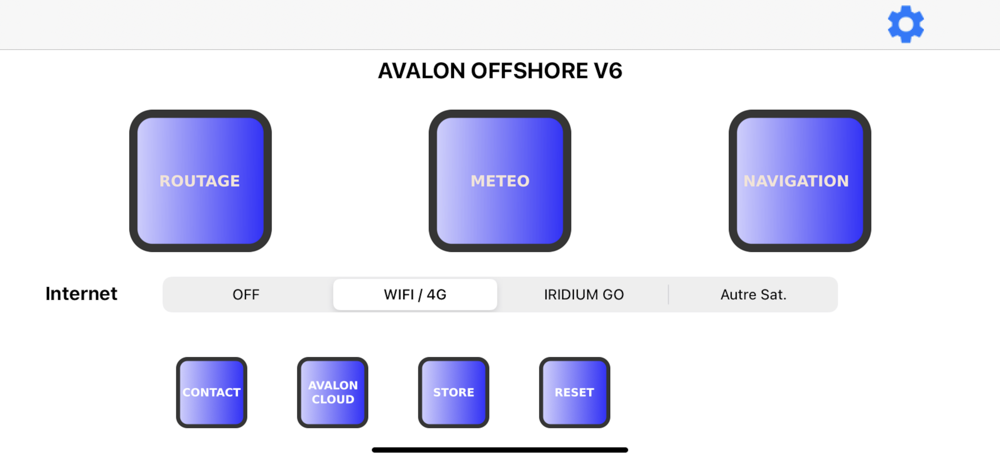
Avalon Offshore
Avalon Navigation Systems
4.2
AD
Detalhes da Versão
| País do Editor | FR |
| Data de Lançamento no País | 2015-06-18 |
| Categorias | Weather, Navigation |
| Países / Regiões | FR |
| Website do Desenvolvedor | Avalon Navigation Systems |
| URL de Suporte | Avalon Navigation Systems |
| Classificação do Conteúdo | 4+ |
AD
Avalon Offshore est un logiciel complet de routage météo et de navigation.
Il fonctionne sur tablette iOS ainsi que sur Mac M1 et regroupe l’ensemble des fonctions utiles aux plaisanciers et aux régatiers: Routage météo, navigation avec connexion NMEA 0183 et AIS, alarme de mouillage, gestion du départ de régate avec affichage des laylines, etc…
Avalon inclut la possibilité de charger 65 modèles météo divers: Arpège, Arome, Icon, GFS, Skiron, …
De plus Avalon inclut certaines fonctionnalités avancées:
- Routage bathymétrique permettant de calculer des routes prenant en compte le tirant d’eau de votre bateau (nouveau)
- Analyse simultanée comparative multi modèle météo et/ou multi option de route
- Logiciel de calcul de polaires personnalisées pour monocoques
- Capture de polaires réelles en navigation (nouveau) pour tous types de bateau
- Compression des données météo (GFS, Arpege, Icon, NAM Caraïbes et USA East) reçues par Iridium permettant de réduire jusqu’à 95% les temps de transmission
-Routage de port à port pour une prise en main rapide du logiciel
Compatible cartographie Navionics Boating sans coût additionnel
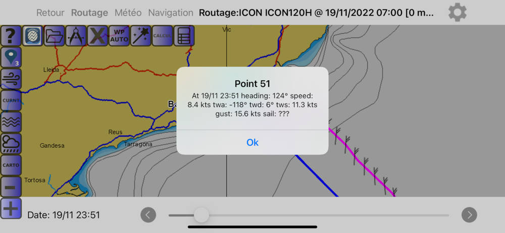
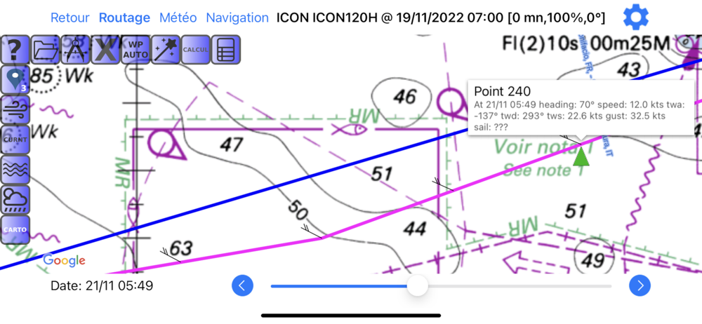
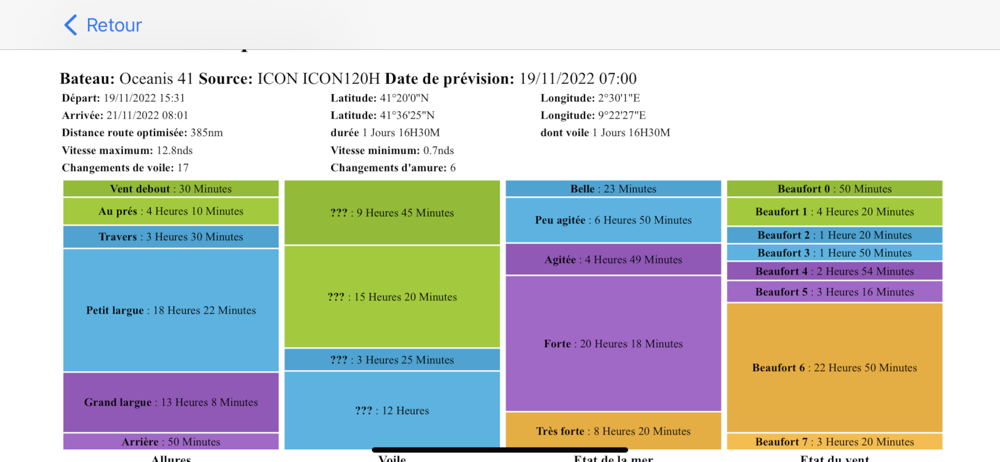
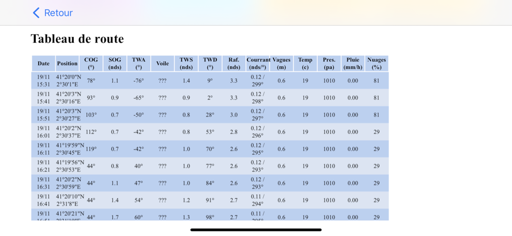
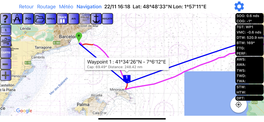
Routage Météo
- Couverture mondiale, régate et croisière
- Calcul de polaires personnalisées (monocoque)
- Prise en compte du tirant d’eau du bateau (France pour l’instant)
- Routage multivoiles, avec possibilité de générer une polaire pour chaque voile à partir d’une polaire composite.
- Routage mixte (voile et moteur)
- Différents niveaux de routage: Débutant de port à port (plus de 1000 ports pré enregistrés), Croisière confirmé et Course
- Positionnement de waypoints automatiques (ou manuels)
- Chargement de données météo en automatique (environ 65 modèles disponibles avec abonnement Premium) ou fichier grib en manuel.
- Compression des données météo téléchargées jusqu’à 95% pour reception par satellite avec 67modèles météo (NOAA GFS, Arpège Europe et Monde, Icon 30h, Icon 120h, NAM Caraibes, NAM USA)
- Analyse simultanées de scénarios de route (options de route, différentes sources météo, décalage vent, efficacité polaires)
- Affichage des données ports et mouillages Navily ©
-Synthèse de croisière avec comparaison entre route directe et optimisée.
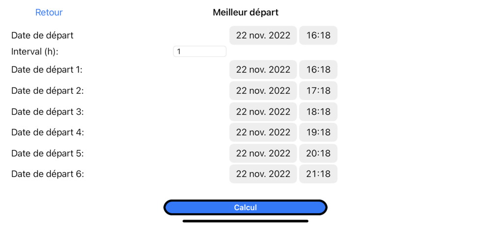
- Calcul de l’heure de départ en fonction de l’heure d’arrivée souhaitée.
Cartographie
- Interface Navionics© sans cout additionnel avec abonnement Boating
- Packs de cartes SHOM© à l’achat
- Packs de cartes UKHO© à l’achat
- Cartes USA, Brésil, Nouvelle Zélande et Argentine pré-chargées (gratuites)
- Compatible mbtiles et autres cartes raster (kap, geotiff)
Polaires: personnalisées (adaptées à votre bateau) et/ou Acquisition de polaires en mer
- Fonctionnalité gratuite disponible sur le web avec un interface automatique avec la tablette
- Calcul de polaires par jeu de voile: Grand Voile + Génois, Trinquette, Code 0, Spinnaker, Spi Asymétrique, Artimon
- Permet l’affichage de la gite prévue et de la prise de ris dans le routage
- Monocoques: Sloop, Ketch ou Goelette (grement moderne). Attention: Ne fonctionne pas pour les multicoques. Il faut utiliser des polaires standard
- Capture de polaires en mer
Météo
- 65 sources météo automatiques avec l’option Premium.
- Affichage statique (point fixe) ou dynamique (synchronisée avec le bateau)
- Météogrammes synchronisés avec la position du bateau
- Affichage barbules ou nuages de points (comètes)
Départ de Régate
- Positionnement ligne de départ et bouées de parcours
- Affichage de la position prévue de l’étrave au top départ et du temps à courir
- Affichage des laylines
- Attention: Nécessité un GPS performantouver
Confidentialité: http://www.avalon-routing.com/newfr/confidentialite/
Download Avalon Offshore
Not Available
Avaliação Média
35
Desagregação das Avaliações
Avaliações em Destaque
Por Courtox
2020-08-09
Versão 4.1.0
social_and_communityAvalon permet d’essayer virtuellement différentes solutions pour aller d’un lieu à un autre. La comparaison de ces tactiques est intuitive. On peut imposer des waypoints de type portes pas seulement des points. Ensuite il suffit de faire son choix de « skipper » en imposant la route réelle en posant quelques waypoints Idéal pour le navigateur qui aime réfléchir sur la navigation en fonction des éléments variables de la météo et des courants Le coût des cartes du SHOM est raisonnable, on peut aussi utiliser sa licence Navionics de l’application Boating pour disposer de cartes mondiales sans ajouter de dépenses Merci
Por 9juin2023
2025-07-19
Versão 7.1.0
designserviceBonjour, Oui très bel outil qui dénote bien l’engagement marin des développeurs. Beaucoup de belles et puissantes fonctions accessibles par des menus et icônes synthétiques qui évitent la sensation de devoir errer dans une forêt trop dense. Dans les projections de croisières où régates cette application apporte de la sécurité en encadrant les paramètres de navigations saisis. Par exemple en autorisant, et sans pertes de données, des allers retours dans les fonctions, quand « ça bloque » pour raisons, par exemple, de limites ou bornes entrées précédemment. Très grand choix de modèles météo et possibilité de se projeter loin dans le futur de sa navigation en voie d’être. Belles facilités d’apprentissages pour un utilisateur nouveau. Véritable compagnon avisé … intégré de météo, routage-projection, et mise en œuvre en navigation. J'apprécie beaucoup, quand bien même ayant commencé à naviguer dans ces années où le système GPS américain Transit ( dispo. Pr moi Vers 1978 env.) mis encore 15 ans pour être disponible… Bien cordiales salutations à vous et belles navigations. Francis Benoit
Por pknzip
2025-02-22
Versão 7.01
Après une rapide prise en main, l’application est simple d’utilisation et les calculs de routes sont rapides et pertinents… J’ai au début eu un petit souci pour l’installation sur un deuxième appareil (de ma faute je dois l’avouer); j’ai donc envoyé un message pour demander de l’aide et j’ai très rapidement été contacté par Philippe qui m’a résolu le problème avec professionnalisme et sympathie…
Capturas de Tela

Apps Populares